|
WEICHERT, REALTORS� - SouthShore
Real Estate News
Find out what's happening in real estate.
|

|
Canada's Atlas Now 100; Topographic Maps Go Digital
Atlas of Canada just released its next generation of digital topographic maps as free downloads.
MAR 14, 2006
Realty Times
Most Canadians were first introduced to their country as school children through their Atlas of Canada. The big, pale pink land mass that was identified as Canada in printed books has now emerged in digital format with free online access -- and every colour under the sun.
This year, Atlas of Canada celebrates its 100th anniversary with a commitment "to provide the most interesting, dynamic and comprehensive collection of maps and related information about Canada available anywhere on the Internet, with effective and intuitive tools for users to access them."
The First Edition of the Atlas was published in 1906 when Canada was a nation of 7 million, 70 percent of whom lived in small towns and rural areas. The Sixth Edition, launched on the Internet in 1999, was one of the world's first electronic online atlases.
The 2006 edition represents a departure from the paper map to a dynamic collection of interactive maps, graphics, images and multimedia resources. Atlas renderings, based on Web Map Service (WMS) software, are no longer maps in the traditional sense of the word, instead they are gif files which integrate and overlay data and layers from diverse sources. For instance, digital topographic maps draw on over 13,000 individual maps. Although printed versions are accurate up to the time of printing, digital maps are continually and automatically revised as new source information is available.
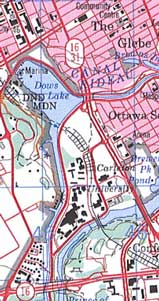
One Atlas anniversary project involved the recent release of the latest generation of topographical maps for all of Canada. Digital Toporama maps represent free access to the National Topographic System in an easy-to-use mapping tool. Maps depict, in detail, ground relief (landforms and terrain), drainage (lakes and rivers), forest cover, administrative areas, populated areas, transportation routes and facilities (including
roads and railways), and other constructed features.
A 1/50,000 scale topographic map, which covers an area approximately 1000 square kilometres, accurately shows hills, valleys, lakes, rivers, streams, rapids, portages, trails and wooded areas as well as major, secondary and side roads and all man-made features including buildings, power lines and dams. This scale is useful for governments, businesses and consumers in varied applications:
- Disaster prevention, environmental management and emergency relief such as flood control and forest fire control
- Development and land use such as real estate planning, development of natural resources, environmental issues, right-of-way, highway planning and depiction of crop areas.
- Recreational activities such as cycling, canoeing, snowmobiling, fishing, camping and hiking
- Communication projects, including directions for visitors.
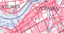
A 1/250,000 scale topographic map provides a detailed overview of a large area. These maps cover the same area of land as sixteen 1/50,000 scale maps or an area approximately the size of Prince Edward Island.
Here's some how-to ideas for Toporama maps:
- Explore Topographic Maps
- Search for Names -- city, town, lake or other feature etc., if necessary.
- Use Topographic Maps using word processing or drawing/image software, select an image, copy it, and paste it into your desk application or copy it to disk. Maps may be modified. For instance, Toporama has applications in geography and mapping as a background map to which other information can be added.
- Topographic Mapping Tool Help, just in case.
The Canada Map Office no longer distributes printed maps directly to the public, but uses a dealer network available through the Yellow Pages.
Those interested in Digital Topographic Data have four sources to search:
- Topographic: National Resources Canada's Centre for Topographic Information is responsible for the acquisition, management and dissemination of topographic information, including free Toporama maps.
- Quality, free geospatial information with unrestricted use -- GeoBase is a federal, provincial and territorial
government initiative "to ensure the provision of, and access to, a common, up-to-date and maintained base of quality geospatial data for all of Canada." For example, almost 1.1 million kilometres of the
national road network, spanning all Canadian provinces and territories, are available for free downloading.
- Data for purchase -- The National Topographic Database is a digital database for the entire Canadian landmass under themes which include Hydrography, Vegetation, Power Network and Manmade Features.
- Free geospatial data -- GeoGratis is a web and file transfer protocol (ftp) site that distributes geospatial data of Canada to a wide variety of clients familiar with geographic information systems (GIS) image analysis or desktop graphics.
Copyright � 2006 Realty Times. All Rights Reserved.
|
|
|
|
|
Home Advice
Get the answers on home selling and buying.
|
|
|
Independently Owned and Operated
Copyright �2000-2006 Homes.com, Inc. All Rights
Reserved. Privacy Policy, Full Terms
and Conditions.
HOMES.COM
is one of the
largest Internet real estate sites with hundreds of thousands of homes for sale and apartment rentals with photos,
descriptions, and relocation services. The advertisers and publishers are not responsible or liable for misinformation,
misprints, or other errors. All information provided is deemed reliable but is not guaranteed and should be independently
verified. Properties subject to prior sale or rental.


templates/weichert-office-enhanced-02
|
|

|